Rysy 2503m, High Tatras

Rysy is another iconic peak of the Tatra Mountains, located on the main ridge along the Slovak–Polish border. It holds several notable distinctions: it is the highest mountain in Poland, the highest border crossing in the Tatras, and the highest—and most frequently visited—peak in the range that can be reached by ordinary hikers on foot, without the use of a cable car or a mountain guide.

Rysy has three summits: the north-western viewpoint summit on the border, the central (main) summit, and the south-eastern summit, which is the lowest. On the Slovak side below the peak lies a group of three glacial lakes known as Žabie plesá, which make an excellent rest stop on the ascent.

As we completed our hike to Krivan, our friend Lubo – “Santo”, just texted us whether we won’t be going to Rysy any soon. As a coincidence Miska wanted to make it too and while I was undecided, Santo became the decisive element.

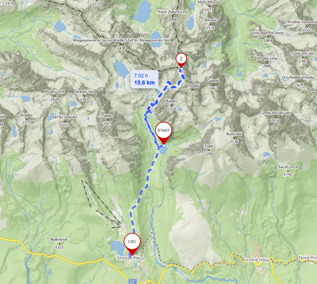
In the late afternoon on 18th of September we drove from Levice to Strbske pleso, High Tatras. Left our car on an empty main parking space and got a shuttle van to the hut – Chata Pri Popradskom plese. This is very well modernised hut with great kitchen for reasonable prices.

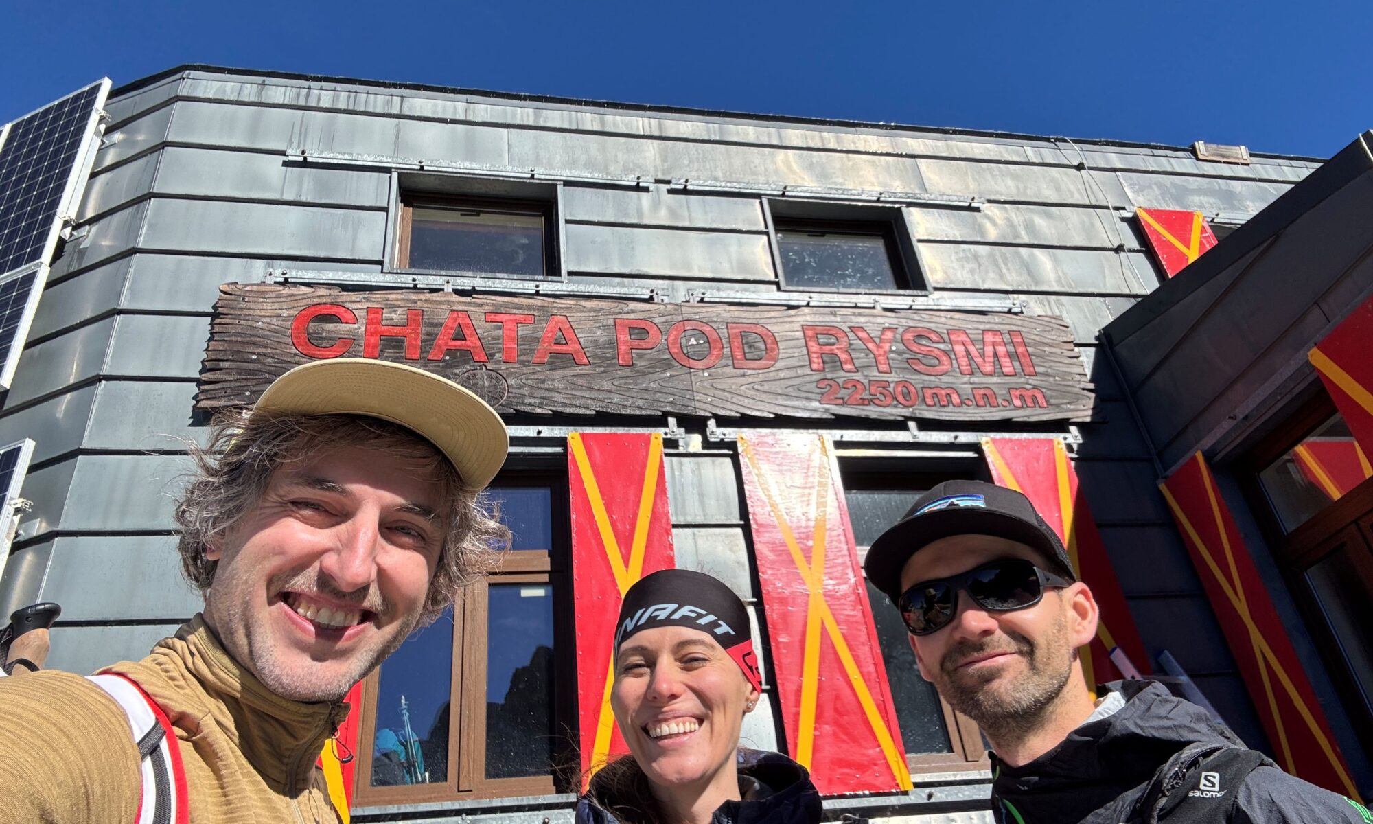
On the Friday morning on the 19th of September, it was already quite cold, at least not raining, so we began the hike at about 7:00 am. Soon we were ascending the Mengusovska valley and reached Žabie plesá. Afterwards there is short part with ladders secured by a chain before you reach very famous hut – Chata Pod Rysmi. It’s the highest-altitude mountain hut in the Tatra Mountains, sitting at 2250m and also the youngest, having been built in 1933.

From there it’s just those last few (250) ascending meters to reach the summits. All 3 peaks offer stunning panoramic views, stretching across the High Tatras onto e.g.: Ťažký štít, Lomnický štít, but also Morskie oko in Poland.

This hike takes from Chata Pri Popradskom plese to Rysy and back to Strbske pleso around 16 km and we managed it in 8 hours, 23mins with 1038 m overall elevation gain.   

Kornati Yachting with Friends

Ready for another great adventure!? The dates were settled, destination and yacht chosen and Tomas prepared a wonderful Itinerary booklet!

At half past one, on 19th of August we all (Tomas+Lenka, Igor+Andrejka, captain Senko and us 2) met up in Sukosan – Marina Dalmacija – the greatest marina in Croatia.

Finishing the shopping procedures, checking in and on the boat, we were about to leave the place. However, as the marina was fully occupied and Senko needed to refresh his driving skills, we slightly hit a catamaran parked on the opposite pier 😱… Hopefully nothing got damaged!😇

Obviously, it took us some time to shake off the tense situation, but leaving the land in distance we just hop in the yachting joy.⛵ Saturday’s ride was reasonably a shorter one, but included a free program evening for the crew.😊

On Sunday we arrived to the snorkelling spot (potonuli brod S Michale) and then parked on a buoy near Veli Rat marina. For Monday we had the highest peak set for a goal. Although there is no track, not even a trace, we still managed to get some amazing views from the top of otok Katina. Later on, we visited the Telasica national park and its peaceful lake Mir.

On Tuesday we were up and sailing pretty early. Our first stop was Fort Tureta on otok Kornat with it’s ruins and picturesque little church. Then we managed to get a buoy in pretty crowded Levrnaka bay, just next to the fabulous Lojena beach, which we also enjoyed a bit. Afterwards, there was a party!!!  📣💃🎵

The next day we headed first to see the otok Lavsa and had a break in Konoba Larus. There, we decided to go and buy some more stuff in Piskera marina. For the evening we parked by uvala Korobacna, not the calmest one.

Sixth day on the sea we sailed along the east side of otok Kornat to the north. There we stopped for a lunch in a tiny bay, but continued further to ACI Marina Zut. Here I drank some water from the shower rooms and went off for the rest 🤢…  Unfortunately, cause Friday was a lovely day too. The highlight surely was otok Vrgada with its truly real sandy beaches. But the next stop was the unpopular one – petrol station. After an hour or so, we finally got what we needed and despite it was close, we did not crash. Furthermore, we came back to Dalmacija marina and parked the yacht in some great manners!

However, this was the last part of our great Kornati adventure. Thanks God! We all survived and even returned the yacht completely. Thank you, captains and the crew!🤗👍 Let’s repeat soon!

Cesta Hrdinov SNP

Stretching all the way from North-East to very West – almost through the whole country – the most important touristic route’s name stands for “Trail of the Slovak National Uprising Heroes”.

In regard to its length (approx. 760 km), one can obviously choose a part of it for hiking and not necessarily walk out for weeks. Tomas has done all the planning superbly.

Our journey begun in Donovaly and continued through the crest of Low Tatras towards Chopok. Oversleeping the first night in “Hiadelske sedlo” we changed the plan a little bit, so the shelter at “Durkova” was luckily switched by the last room in Magurka (the highest situated settlement in Slovakia). Although Chopok was not far away the next day, those cold weather conditions obstructed the way badly. Even a group of chammies watched us surprisingly coming that late in heavy fog.  We honestly deserved some comfy sleep at the premises of “Kamenná Chata”. For the last – 4th day there was just an easy downhill track to Certovica on the plan. However coming down limping with some bloody blisters, we had absolutely enough. Better results are promised next time!

Sankt Gallen, Gesäuse

And the first post is here! Please enjoy. Longer Austrian weekend from 10th to 13th of May we spent in a small village of Sankt Gallen (Styria, not the one in Switzerland 8) which is a part of Gesäuse National Park. We have been hiking in the park and completed around 40 km, all mainly uphill. A beautiful piece of country!